What makes this trip special?
Explore the Carretera Austral
The Aysen region
The Marble Cathedral
Marble Caves on Lake General Carrera
Itinerary
-
- Day Overnight
-
1
Coyahaique
-
1
R7 turn on C Austral
-
2
R7 turn on C Austral
-
2
Puerto Guadal
-
3
Puerto Guadal
-
4
Caleta Tortel
-
5
Cochrane
-
6
Puerto Guadal
-
7
Balmaceda
-
7
R7 turn on C Austral
-
- For the detail of each day click the ‘Day-by-day’ tab above.
Day-by-day itinerary for 'Driving the Carretera Austral'
Coyhaique to Puerto Guadal
Puerto Guadal to Caleta Tortel
Caleta Tortel to Cochrane
Cochrane to Puerto Guadal
Guide prices for 'Driving the Carretera Austral'
| options |
based on |
all year |
low season |
mid season |
high season |
peak season |
other season |
| mid-range hotels |
2 people sharing |
£1,200 |
|
|
|
|
|
Prices are per person and include:
- all accommodation
- category G rental car with unlimited mileage for 1 named driver and basic insurance
- all other travel in Chile
- meals as indicated (B = breakfast, L = lunch, D = dinner)
Prices do not include:
- international flights
- travel insurance
- airport and departure taxes
- items of a personal nature such as drinks, tips, laundry, etc
- any optional excursions you may buy locally
Customer reviews for
'Driving the Carretera Austral'
Recent reviews are shown here from holidays based on this initial design. In each case the itinerary may have been modified
(a little or a lot) to suit the individual traveller.
Seasonal information for 'Driving the Carretera Austral'
Hotels for 'Driving the Carretera Austral'
Day 1
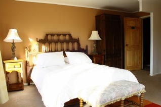
Double room
Days 2 - 3
Mirador de Guadal
Puerto Guadal
El Mirador de Guadal is reached by the Carretera Austral and stands on the southern shore of the General Carrera Lake with views over the water and glaciers of the southern ice field. This small hotel has 9 cabin style rooms with a small living area, private terrace and access to the lakeside. Each cabin is named after a regional plant or animal. The larger suites can accommodate up to four people, and are located by the edge of the lake. The hotel’s restaurant serves Chilean and international dishes using many ingredients from the lodge’s garden.
Superior room
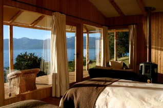
Day 5
Ultimo Paraiso
Cochrane
Hotel Ultimo Paraiso is small hotel with six bedrooms with private and fully equipped bathrooms with heating, Wi-Fi, phone and satellite TVs. There is a communal living room with TV and bar area, as well as free parking and a laundry service. The hotel is also on hand to help guests with booking excursions locally to the nearby National Parks and glaciers through their tourist information service.
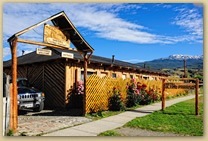
Hotel entrance
Day 6
Terra Luna Patagonia
Lake General Carrera